Honor Marine
Home Yachts Fishing Fleet Commercial Military Captain's Quarters

Visit us on Facebook


NavNet vx2 - GPS/WAAS Chart Plotter - GP1920C

Display Power Use Receiver Type
10.4" Color LCD 12 or 24 VDC WAAS/GPS

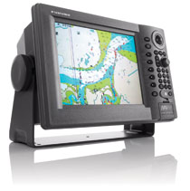
Since its release back in 2001, FURUNO’s NavNet series has been enjoying unrivalled popularity worldwide for its high reliability, performance and expandability. It has even been voted Best Integrated Navigation System by the National Marine Electronics Association for three consecutive years. Now, NavNet vx2 is ready to carry on the tradition.

NavNet vx2 combines radar, GPS/WAAS chart plotter, fish finder, and network weather facsimile into an all-round navigation network. Its wide range of options fulfils virtually every desire you may have for navigation system.

Radar, GPS, Network fish finder, Network weather facsimile - a multistation integrated navigation network, NavNet vx2 lets you build your navigation system according to your needs. Utilizing state-of-the-art network technology, NavNet vx2 provides you with seamless data sharing and vast future expandability.

The heart of NavNet vx2 is its Ethernet-based network. Up to four displays, together with various navigational sensors, can be interconnected in addition to new MaxSea-NavNet navigational software, which adds even more features to your NavNet vx2 network. Stress-free navigation can be performed from any display unit connected to the onboard network, due to the high-speed transfer of data available.

  • All display units are capable of controlling any component connected to the NavNet network
  • Perfect for single or multi display installations
  • Fully supports Navionics ® GOLD chart.
  • Utilizes SD cards for chart and memory.
  • Fast chart drawing speed.
  • Straightforward “Plug ’n Play” installation with wizard style set-up.
  • AR-coated, high-brightness display unit for improved sunlight viewability.

Chart Plotter Features:

  • Sunlight Viewable VGA (640 x 480) Display
  • Front loading Mini-Chart Card port
  • Fully compaitible with Navionics GOLD charts
  • Simplified installation with new “Network Wizard” set-up
  • Cursor L/L Position Display **
  • On-Screen Display of Vessel Position, Heading, etc. *
  • Vessel Position Display in L/L or Loran-C TD's
  • North-Up, Course-Up or Automatic Course-Up display modes
  • Plotter, Nav Data, Steering Director or Highway display modes
  • Up to 8,000 points for ship's track and marks, 999 waypoints, 35 quick points, 1 MOB, 200 planned routes (max. 35 waypoints/route) and 1 quick route
  • Add Multiple Displays by Connecting to NavNet Interface
  • Add Network Sounder by Connecting to NavNet Interface
  • MOB Key Stroke stores Vessel position and time
  • Plotter Range Scales from 0.14 to 6,144 nautical miles
  • 16 different mark symbols may be used
  • Waypoint entry by L/L position or TD position or target Range and Bearing
  • Plotter position interval may be set by Time or Distance Traveled
  • TLL position from specific Furuno Radars or Echo sounders
  • Full Functioning Infared Remote Control

GPS Features:

  • Integral parallel tracking GPS/WAAS receiver
  • Up to 900 knot tracking velocity
  • 20 seconds for first position fix
  • GPS position accuracy of approximately 10 meters, 95% of the time with S/A off
  • WAAS position accuracy of approximately 3 meters, 95% of the time with S/A off

Power Requirements:
 
          12 or 24 VDC


Honor Marine Electronics
1804B Cleveland Ave - National City, CA 91950
Phone: (619) 233-7666 Fax: (619) 231-0397

Web design by Webpublishing.com